It’s a day off and I’m awake before sunrise. This time of morning on the West Slope of the Sierra Nevada, it won’t be light until the sun creeps above its soaring peaks. I like it this way. It’s a two-hour drive over Sonora Pass before dropping into the starkness of the Eastern Sierra. It’ll be a murky twilight until I crest the pass.
I shower and dress, gather my breakfast for the road, and quietly close up the cabin. There is just enough light to find my way across the deck and down the stairs. In the pre-dawn stillness, pine needles crunch loudly under my boots.
I pull the car out of the driveway and lock the gate. After two right turns and a left, I’m headed east on Hwy 108. It’s an easy drive this morning. Only four cars on the road, three in the opposing lane and the other only a momentary companion. This is a familiar road, but it’s winding through forests rendered unfamiliar by the need to remove trees killed and now kindling after an onslaught of bark beetles.
There’s no hurry this time. I know a few pockets of the Eastern Sierra. Loosely defined as stretching from Lone Pine in the south to the Nevada state line to the north and east, much more of it remains unknown to me. Secure in the knowledge that I’d hook and land a trout or five – or simply cocky – I had decided that this would be a trip that included explorations that probably wouldn’t include fishing, much less a fish.

Sonora Pass: It’s all downhill from here.

The historical landmark sign at Sonora Pass. The power of heavy snowfall.
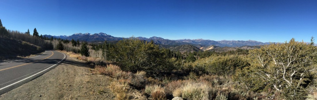
It’s become my tradition upon reaching Sonora Pass to stop for a moment. This year, there’s clear evidence of the heavy snows of last winter. One side of the historical landmark sign is leaning about 15 degrees. A few snow fields remain where last year were none. Absent any human traffic, natural noises abound. Birds scurry in the brush. The wind makes that rushing sound that seems to be specific to high Sierra pines. The almost treeless land to the east is lit by harsh sunshine. The west is still in the shadows of the peaks and trees.
Stopping at the Leavitt Falls Vista Point, I look down upon the West Walker River. Even at 7,800 feet, 1,000 feet above the river, I can see that it’s full of water. The first people I see are a few miles down the road – packers at the Leavitt Meadows Pack Station. A short stop at Pickel Meadow Wildlife Area confirms that the West Walker River isn’t ready to be fished.
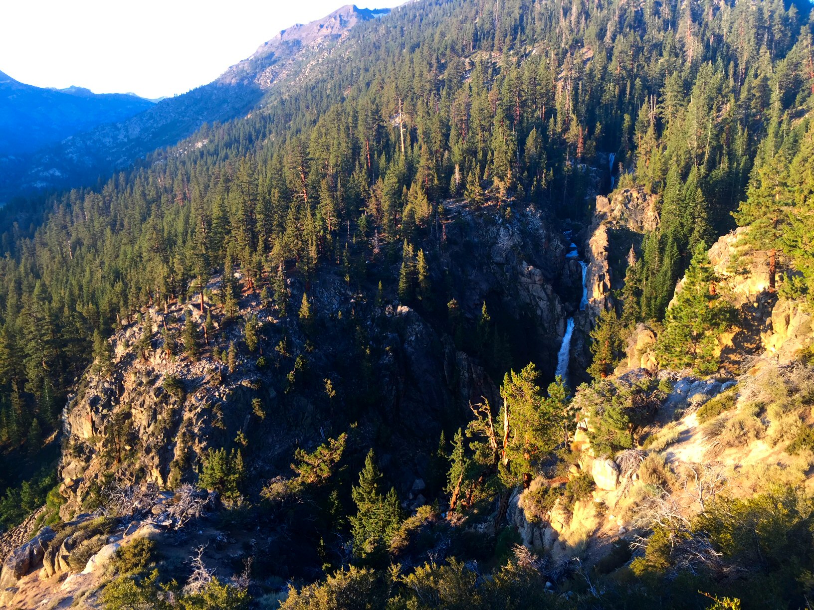
Leavitt Falls in the early morning light.
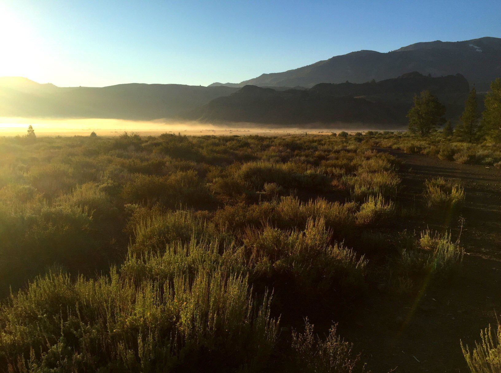
Fog and cows on Pickel Meadow.
I drive on. I pass the oddly quiet Marine Corps Mountain Warfare Training Center. A right turn onto Hwy 395 marks the beginning of long, flat roads. It’s still cool enough that steam rises from Fales Hot Springs. Soon I’m through Bridgeport, across the East Walker River, and southbound.
Scattered trees give way to dry high desert. Only in the canyons west of the highway do trees – mostly aspens and pines – find enough water.
South of Mono Lake lies the first exploratory attempt. John, the leader of our little group that’ll be spending a few days terrorizing fish in and around Crowley Lake, suggested a stop at Rush Creek. Originating at about 13,000 feet near Mount Lyell, various feeder streams from Marie Lakes and Davis Lakes combine to form the main stem of Rush Creek, which flows through Waugh Lake, Gem Lake, and Agnew Lake on its way to the June Lake Loop. There it enters and exits Silver Lake, then Grant Lake, before finding its way to Mono Lake.
As a teenager camping at the Silver Lake Campground, mysterious fly fishermen would wade downstream and later reappear with big brown trout. Having never returned to June Lake Loop since then, and since I’d become a passable fly fisherman myself, I thought it was about time for a closer look at Rush Creek. Like many creeks and streams here, Rush Creek is lined by brush dedicated to preventing molestation of fish that might be present. If that weren’t enough to dissuade my thoughts of making of a few investigative casts, the creek – which carries 41% of Mono Basin’s runoff – was filled bank to bank with whitewater, the result of accumulating runoff from last winter’s heavy snowfall over its 27-mile course.
I pull back on to the highway and mull over the idea of returning to June Lake Loop in the future without deciding whether that will be on my own or as the leader of a club trip. Once past the northern turn for June Lake Loop, the miles seem to pass quickly. The asphalt here is smooth and the road relatively straight. It slowly rises and falls, passing through infrequent stands of pines. Unimproved roads regularly sprout from either side of the highway. Calling them dirt roads would give the wrong impression; here they cut into an almost white, gravelly, sandy soil.

It’s become something of a tradition to stop at the Tioga Gas Mart, after a trip many years ago with Christopher, to indulge in this sugary treat.
I turn down one with a sign pointing to Lower Deadman Creek Campground. It’s about two miles before the turn into a small basin that contains the campground and the creek. Here the chaparral gives way to pines. The campground straddles the creek; four of its thirty sites are occupied, but the abundance of water this year makes half the sites unusable.
I geek gear up, stopping to talk with a grad student who’s studying the geology of the area. He points out where he’s seen stocked fish:the likely places – long runs that curve through the campground. Here, towering pines shade this place, allowing the coolness of morning to linger long past sunrise and muffling the sounds of coffee being poured into a mug, a spoon clinking against a cereal bowl, a father beginning to pack the necessities of camping, the grad student strumming a guitar.
Deadman Creek is much like many Sierra creeks I’ve fished. Its clear water ebbs and flows, tumbling over rocks into bubbling pools and carving out channels under tree roots. I think my 3-weight Winston maybe a bit too much rod for this stream but know its length will come in handy when it comes to poking through the brush that lines the banks of this creek.
I’m here looking for the wild trout that are rumored to be in the upper reaches of Deadman Creek, but I can’t help warming up my casting arm tossing my flies to a few of the human-raised rainbows. My cast is rusty but good enough to lay my flies down on a seam that carries it over a few fish fighting for position in the current. There’s no subtlety about the stocked trout. The lead fish slashes at my dry fly and the other fish scatter. The skunk is off.
The hike upstream makes me grateful that I walk every day. The campground is at 7,800 feet, and I’m headed higher. Half a mile upstream I’m alone. Ripe bitter gooseberries stand out among sage, bunch grasses, willows, and rambling wild rose bushes.
The creek from this point and upstream is no more than three feet wide. I find the wild brook trout that lured me here in nearly every plunge pool and tail-out. There’s contentment to be found in a wild place such as this, and when found it’s the simply being in that place that’s enough.
I turn downstream after about two miles gained in small increments dictated by fishable water. In this canyon it’s either night or day, and during the day there is no sense of time passing in its unchanging shade. It’s just before noon when I get back to the car.
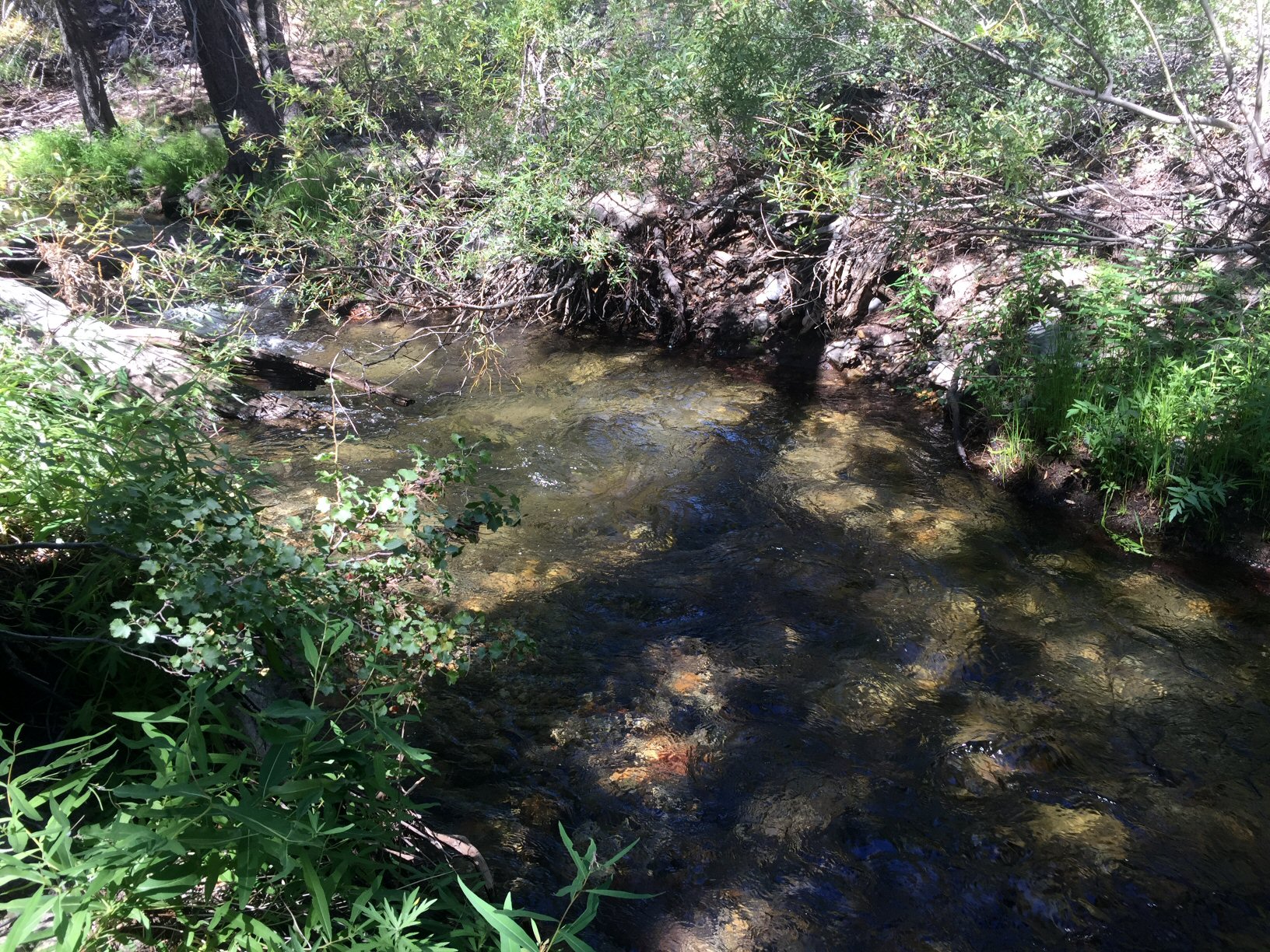
One pool on Deadman Creek that gave up a brook trout, as it should have.
It takes less time to travel the three miles of dirt road to the highway than the 23 miles to the Hot Creek Interpretive site, another place of exploration this trip. I’ve fished the canyon section of Hot Creek, but this section is unfamiliar and different. The unwelcome sight of four trucks already parked in the turnout makes me question my decision to stop here. It’s not a long stretch of water, about 2,000 feet, meandering through fields of sedges.
The reports were true; it’s grasshopper season. I disturb half a dozen every few steps. A dry-dropper setup is my go-to option for Hot Creek. A dry fly – in this case a grasshopper dry fly – to get the attention of fish looking up, and a nymph to get the attention of the greater number of fish hiding beneath Hot Creek’s plentiful aquatic vegetation. This vegetation is partially responsible for making Hot Creek one of the most productive wild trout waters in California, and the single reason it can be difficult to fish. (Thankfully, as a designated wild trout stream, no bait allowed, only artificial flies and lures with barbless hooks, and all catch and release.) Even so, it’s one of the most heavily fished wild trout waters in the state.
Two fishermen downstream force me upstream. The flow’s a bit high, and getting a drag-free drift is not easy. After five casts, I move downstream. On Hot Creek, I favor a mid-stream stretch that offers a clear lane between vegetation, close enough that a raised rod can keep most of the fly line off the water. Maybe it’s a confidence thing, but once I find one of those lanes, I get a few takes. It’s a mix of hits on the dry and subsurface flies, but all come up short.

Great day on Hot Creek. Not so great catching.
It’s not until I’ve leap-frogged past the two fly fishermen – who haven’t moved since I arrived – that I find more willing fish. Just above the fence that marks the private Hot Creek Ranch property, a number of fish hide in the weeds. A fly placed close enough elicits strikes and, with enough casts to the right place at the right time, it’s inevitable that I land one. It’s a small fish by Hot Creek standards, maybe 10 inches, but satisfying.
The sun’s high in the sky now, suggesting that it’s time to meet the rest of the guys at Tom’s Place, just a few miles down the road. Along the way I pass McGee Creek and Crowley Lake. Both are brimming with water this year, and I plan to fish both.