fishing for words

(and tossing out random thoughts)


Leave a comment

you may have to carry a fire extinguisher to hike high enough to find Sierra Nevada trout

ICCC Report CoverFollowing up its good news/bad news report on Lake Tahoe, the California Office of Environmental Health Hazard Assessment paints a bleaker picture in its August 2013 Indicators of Climate Change in California.

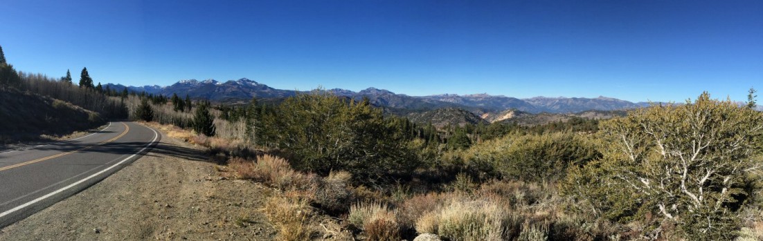
To sum it up, analysis of monitoring data and scientific research from throughout the state outlines the effects of climate change: The spring runoff in the Sierra Nevada has declined over the last century. The period of time when winter temperatures in the Central Valley are cold enough for the development of fruit and nut tree flowers has been decreasing since 1950. River runoff declined during the 20th Century:

River Runoff Percent Decline
in 20th Century
Sacramento River System* 9%
San Joaquin River System 6%
Kings River 6%
Kern River 8%
Mokelumne River 7%
Trinity River 8%
Truckee River 13%
Carson and Walker rivers 5%
*includes the Sacramento River and major tributaries, the Feather, Yuba and American rivers.

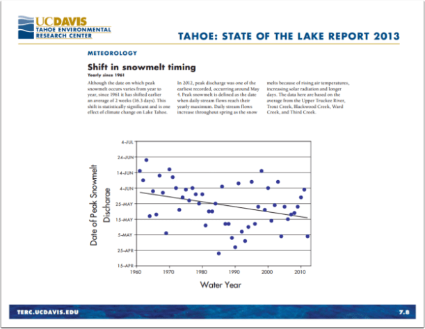
Changes in average temperatures have led to die-offs of native vegetation at the lower range of various species’ elevation range (during the last six decades Sierra Nevada conifers have clearly retreated upslope) and is pushing about half of the small mammals in Yosemite National Park to higher elevations. The annual acreage burned by wildfires in the state increased since 1950, with the three largest fire years occurring during the last 10 years. The acidity in the coastal waters around Monterey Bay is increasing at a rate greater than that in the open ocean near Hawaii. The average annual temperature in mountain lakes, including Lake Tahoe, has risen over the last few decades.

And butterflies are emerging earlier during the spring in the Central Valley.

Yet, there’s no real trend that can be discerned from the data. The rise in the sea level rise along the California coast is bucked the global pattern and has be relatively constant during the last two decades.

Cheery stuff.

Advertisement


Leave a comment

maybe you’d better fish those Sierra lakes while you can

The good news is that the clarity of Lake Tahoe improved last year. The bad news is the whys. Precipitation in 2012 was only 71% of average and there was a lack of “deep mixing” during the winter.

While the lack of precipitation means pollutants flowing into the lake, the lake will lose shoreline with any prolonged drought.

And, maybe you'd  fish those rivers, streams and creeks a bit earlier in the year.

And, maybe you’d fish those rivers, streams and creeks a bit earlier in the year. Snow in the Tahoe Basin is melting nearly a month earlier than it did in 1960.

The lack of deep mixing – cool surface water sinking and forcing nutrients deeper in the lake to the surface, also know by fishermen as “turnover” – suppresses algae growth, which would otherwise cloud the water — but that also means warmer water temperatures. The annual average surface temperature of Lake Tahoe last year was nearly 53 degrees – the highest ever recorded.

Perhaps the scary part is a few lines in the intro to the report written by Geoffrey Schladow, Director of the UC Davis Tahoe Environmental Research Center:

“While Lake Tahoe is unique, the forces and processes that shape it are the same as those acting in all natural ecosystems. As such, Lake Tahoe is an analog for other systems both in the western U.S. and worldwide.”

You can read the relatively short report update here.


1 Comment

…and eventually they’ll plant banana trees next to former trout waters

Us fly fishers can safely assume trout will be where we left them last season, but the clock ticked a minute closer to the Outdoor Apocalypse with the new version of the U.S. Department of Agriculture’s “Plant Hardiness Zone Map.” Welcome news for gardeners at more northerly latitudes, to be sure, but I for one am not looking forward to roses and magnolias crowding the banks of Sierra streams any time soon.

And though the USDA website notes…

Climate changes are usually based on trends in overall average temperatures recorded over 50-100 years. Because the (new map) represents 30-year averages of what are essentially extreme weather events (the coldest temperature of the year), changes in zones are not reliable evidence of whether there has been global warming.

– via USDA Agricultural Research website

…the new hardiness map shows a decided shift north nationwide.

And while these warmth loving plants won’t give triffids any competition, by the time they show up next to my favorite trout waters, it’s likely the trout will be gone and the water rendered unfishable by an invasion of members of the Centrarchidae family.

The USDA interactive map can be seen here.