Our days were measured by trout caught, bears seen and miles hiked; nights by stars and the embers of a campfire. During those summers we’d rarely see a familiar face, but the place seemed unchanging. We grew a lot during those short visits, climbing granite domes, hiking trails commonly rising 1,000 feet in less than five miles, floating in a river that only a few miles earlier was born of snowmelt.
I was reminded that Tuolumne Meadows was our vacation “home” last week when I posted a photo of my brother and me with a trophy high-country trout, back when our fishing was more about self-sufficiency and every fish ended up in a pan surrounded by bacon. Mornings my brother, sister and I would hike to Soda Springs to capture the naturally carbonated water – and bits of minerals I’m sure – our mother would gently blend with pancake mix to make some of the puffiest pancakes in the world.
Our visits to Tuolumne Meadows were more adventure than vacation. Stories of our exploits of those summers come up frequently: The poor decision to slide down the granite face of Lembert Dome as the sun set. The bear that followed us back to camp after a long day hike. My sister’s discovery that fish were living beings while ironically still fishing but refusing to eat our catch. On tougher hikes, mom’s constant encouragement to discover what might be around the next bend.
It wouldn’t be out of place to say that Tuolumne Meadows, a less visited part of Yosemite National Park, helped form the person I am today. I’ve since returned to Tuolumne Meadows, one time fishing there with my sons, another time hiking up Lembert Dome with my brother and one son. Nature seems to ignore us humans; the changes over the last three decades are entirely ours.
I’ve been lucky enough to have visited Death Valley, Sequoia & Kings Canyon, Lassen, Redwood and Mt. St. Helen national parks. Many national monuments, recreation areas and historic sites as well: Alcatraz Island, John Muir National Historic Site, Point Reyes National Seashore, Muir Woods National Monument, Cabrillo National Monument, Fort Point National Historic Site and Golden Gate Recreation Area.
The national park system is America’s Best Idea. Next week is National Park Week. Every national park will offer free admission from April 16th through the 24th. If you can, get to one and #FindYourPark.
“Thousands of tired, nerve-shaken, over-civilized people are beginning to find out that going to the mountains is going home; that wildness is a necessity”
― John Muir, Our National Parks
The second day of my Memorial Day trip was undecided until I rolled out of bed that morning. A lot of the time, my angling is a solo affair. There was initial hope that Sean might join me — hitting the high country together is nearly an annual affair — but as happens with kids, they get jobs, take on other responsibilities and interests, and simply can’t always get away. Funny how that works: just as a parent gains a bit more freedom, children tend to lose theirs.
Lyell Fork bridges.
A lack of soreness from the previous day’s hiking encouraged the consideration of another adventure, this time one that would harken back to the adventures of the younger me. During the family vacations in Tuolumne Meadows, we’d often hear about the trail along the Lyell Fork of the Tuolumne River, but a trail I can’t recall ever hiking.
Lingering was nice that morning, but the trail head was about two and a half hours away. I’m pretty practiced at whipping together a lunch and getting the gear ready. The previous day had shown that my Orvis day pack would serve me well, and with only one rod, the other rod pocket kept a water bottle handy. I was on the road about 7:00 a.m. That’s late for me, but today wasn’t to be rushed.
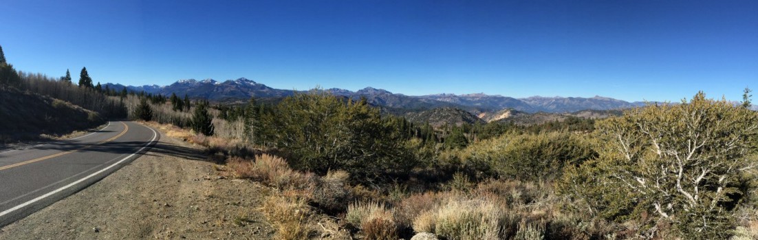
Having traveled the route so many times, it could be said that I’m able to make the drive to Tuolumne Meadows with my eyes closed. But that would be a waste. Though I know what’s around that next corner, each visit offers a new revelation. The Sierra Nevada was called the Range of Light by John Muir for a reason; every view changes, depending upon the season and time of day.
The canyon where I stopped and turned around.
Memorial Day weekend marks the beginning of the camping season, but campsites in Tuolumne Meadows are usually still covered in snow or flooded by snowmelt. There was still traffic, mostly comprised of rock climbers itching for that first touch of that unique Sierra Nevada granite, and sprinkled with the usual sightseers passing through on their way to the valley.
I pulled into the Tuolumne Meadows Wilderness Center just before ten. A line of hopeful backpackers wound around the building, but parking was easy to find. Pack secured and confirming I had the proper map, I hit the trail a few minutes later.
The trail was both familiar and unknown. Many high Sierra trails must look the same at the onset. About a mile along, landmarks revealed this was new ground. There were the rusted steel signs pointing to various destinations, the two bridges that lead to the opposite side of the Lyell Fork, and the river itself, meandering through meadows and twisting through and over the batholith that forms the core of the Sierra Nevada mountains.
This is the type of country that refreshes the soul.
Another view, looking down river.
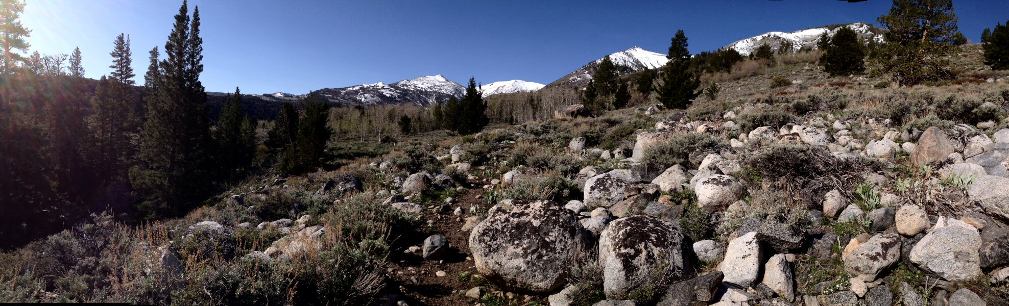
After a mile, I was alone on the trail. The hike was easier than expected. I was inclined to chalk that up to hard-won improvements in my physical fitness — particularly with a trailhead elevation of 8,600 feet — but later determined that the elevation gain was less than 500 feet. Roughly two miles in I left the trail to follow the course of the river. It wasn’t easy. Down trees, boulders and the Lyell’s long elbows required numerous detours.
Further upstream.
About four miles along I came to a narrow canyon. Continuing up river would require a long detour. But I had started a bit late, and daylight can be precious when in the wild.
I rigged up the 3 wt. rod and began that slow walk downstream, presenting my fly to suspect water. The river was high, limiting where a cast could be made without immediate drag.
This is the type of country and the type of fish where stealth pays off. I spooked fish with every step. Where possible, I’d cast four or five feet from the bank, with only a few rises to show for it.
The course of many high Sierra rivers is dictated by huge granite outcroppings, creating pools. In midsummer these pools attract swimmers, but this early in the season it was still too cold for such nonsense. I found one such monolith that directed the Lyell Fork almost ninety degrees from its course, creating a deep pool that offered a feeding lane and overhead protection. Up against the granite was slack water, from which decent sized brook trout would intermittently rocket to the surface.
I tend to avoid putting myself in position to hook a fish without an easy way to bring them to the net. A fishless morning, however, changed my outlook. Moving away from the water and giving the fish a wide berth, I quietly and slowly crept to the top of the outcropping. Carefully peeking over the edge, I could see about half a dozen trout about fifteen feet below. Counting on the height to conceal any false casts, I laid a stimulator in the seam that would funnel insects to the trout. A fish rose, inspected my fly, and dismissed it. That was the pattern on subsequent casts.
Offering a break for both myself and the fish, I sat down to tie on an Elk Hair Caddis. That’s all it took. A nice-sized brook trout nailed it and went wild. It jumped like a rainbow and shook its head like a salmon. My excitement began to change to panic with the realization that there was about twenty feet of line between me and the fish and that I had to lead it thirty feet to my right if there was any hope of getting it to the net. It was a thrilling fight for all of about forty seconds, and I did get a good look at what could’ve been about twelve inches of healthy Salvelinus fontinalis before a not-so-long distance release.
Marmot!?
The tug of that fish — and the fact that I once again was able to fool a wild fish (an accomplishment that continues to amaze me) — made the day seem brighter. I wandered downstream a bit, trying to sneak up on fish in the meadows, and after a few hits but nothing solid, I sat down in the world’s best dining room for a peanut butter and jelly sandwich.
I met more people on the hike out, followed a marmot for a few hundred yards and lingered here and there. It was another day of personal accomplishment. No knee brace was required and my breathing wasn’t labored like it was last year.
Now, I hope to get back when the water’s lower and the fish hungrier.
The beginning of my hike. On the John Muir Trail following the Lyell Fork of the Tuolumne River.
The Dana Fork of the Tuolumne River, I believe.
The hike really begins. I was alone.
Crossing the Lyell Fork.
Lyell Fork bridges.
Rapids on the Lyell Fork.
Further upstream.
The view, looking roughly northwest, from the mouth of the canyon, where I turned around.
My family spent many summer vacations in Tuolumne Meadows. These trips were a family affair and in the interest of keeping everyone engaged, it was more than fishing. We’d spend the days hiking to higher elevations — the campground was at 8,600 feet — and sometimes we’d end up at nearly 10,000 feet. Mepps spinners would be cast into water along the trail and sometimes the destination was a lake where fishing was rumored to be amazing. Mom would keep the troops focused by wondering out loud about what might be around the next bend. My brother and sister and I would spend countless hours exploring the banks of the Tuolumne River, watching the occasional bear that wandered into the campground, and waiting for the rare treat of visiting the campground store, where we’d get to pick one comic book and maybe enjoy an ice cream.
Idealization taints memories but, for me, the Sierra Nevada high country has always lived up to my recollection. That’s what fueled the rest of my plan for Memorial Day Weekend 2014.
The view from where I started.
First-hand reports made it clear that water would be high in the Walker River Basin. But I had a plan that tied into two keywords in my last post: “maturity” and “adventure.” Not to get too personal, but I’m no spring chicken rooster, and for more than five years I’ve worn a compression brace on my right knee. Years ago, while carrying a bag of cement on my shoulder, I stepped into an unseen depression, twisted my knee and fell to the ground. I was young then, so shook it off. It was only years later that I began to feel a bit of pain after long walks. This year I finally got out of my rocker to walk every day. Not Forrest Gump style, but about five miles a day. That, in combination with weight loss, has eliminated the need for the brace.
Cautiously optimistic, in planning for this trip I had decided to walk up the Little Walker River, hoping this would rekindle my enjoyment of high country hikes. I enjoy fishing this creek’s small water, though most of my experience had been limited to the stretch through and downstream of the campground. Sticking to my plan, I ignored warnings of high and muddy water. The drive over Sonora Pass would take about two hours, but it’s one drive that’s always enjoyable as the terrain changes with the elevation and, particularly this time of year, snow still dusts the pass. This day the drive was even more pleasant; being a weekday I saw only four cars at lower elevations, and no one above 6,000 feet.
The section of Hwy 108 between Twain Harte and the junction with Hwy 395 rarely runs straight. It’s a good road and relatively fast considering the twists and turns. On the eastside, after beginning a descent into the high desert, there are at least four severe hairpin turns. It seems that every year I either run into a cattle drive on the highway or a semi-trailer truck stuck at a hairpin. This year it was another truck. I waited about 10 minutes as the driver unsuccessfully tried to free the drive wheels, which had sunk in the loose dirt on the inside of the turn, before walking up to ask if it would be okay to try to drive around on the shoulder. He helped me move a few big rocks. After getting past, I was talking with the driver, emphasizing that this hairpin was only the first, when assistance arrived in the form of a Ford Police Interceptor Utility in California Highway Patrol colors.
The longest part of this drive always seems to be the three or so miles down a washboard dirt road to the Obsidian Campground in the Humboldt-Toiyabe National Forest. It’s not a bad drive, and was made nicer this year by a late-season storm that dropped enough rain to keep the dust down. Best of all: I was the only person there.
One of many fallen trees…
I began hiking where a bridge crosses the Little Walker. Topographical maps showed a nearby trail, but that trail would only appear intermittently during my hike. This part of the river flows through a narrow canyon, and since my preferred tactic is to hike as far up as possible and return by slowly fish downstream, I headed for high ground. This is terrain marked by small and rounded granite cobbles, perhaps glacial debris, sandy loams and decomposed granite. Willow and quaking aspen grow along the creek, replaced by conifers and mountain hemlock, which tolerate a drier environment. Hiking was relatively easy. There’s not much underbrush and the only hurdles — literally — were the many downed trees.
After about an hour I emerged from the canyon to find the wide-open expanse of Burt Canyon. Here the Little Walker meanders through stands of willows. The mountains that looked so far away when I started at about 7,400 feet seemed to be within reach. That was clearly an optical illusion as I was at about 8,600 feet and those mountains scraped the sky. The hiking was easy here and I continued on for about another hour.
I find solitude to be refreshing, so I pulled up a boulder and sat. Handfuls of raisins fed my body. The silence of the mountains, the sound of birds and gurgling water, and the unfathomable history of this place, fed my mind and soul. It was as if I was one of only few humans to pass this way.
The view in Burt Canyon, where I turned around.
Shaking off such romanticism, I rigged up the 3 wt. rod. This is the type of water that begs for a dry fly, with the usual small dropper. I fished suspect water, sneaking through willows as best I could, but apparently not well enough. I re-entered the narrow canyon of the Little Walker River with only a single rise so far.
It took a combination of hiking, climbing and crawling to follow the course of the creek, which wound around boulders, under fallen trees, sometimes cascading ten feet. The water was indeed high. Side arm casting, parallel to the creek was the best option. The fish were there, and a few rose to my fly, but none with enough an appetite to bite. If you fish, you know that there are those special spots that you know must hold fish. During high water flows, those locations change, and observation is the name of the game.
I had taken to hiking above the narrowest sections of the canyon and noticed one such spot. A large boulder was forcing the creek to bend almost ninety degrees, so that even at high flows, a pool was created. A large pine offered shade and security.
Hugging the conifer to hide my profile, my first cast fell into place and the fly slipped along a seam. I let it flow around the boulder until out of sight but before my fly line could spook any fish higher up in the pool. On the third or fourth cast a fish slammed the dry. This wasn’t a long pool, so the fish was resigned to head shaking and circling, but it did stress my little rod. I hadn’t expected to find a thirteen-inch holdover rainbow, but that’s what I was looking at in the net. That pool gave up a few more small fish, wild rainbow and brook trout of no more than eight inches, before I moved on.
Confident these fish could be fooled, it was time to stop for lunch in a small meadow passed on the hike upstream. The entrée was a jelly sandwich — I forgot to buy peanut butter at Twain Harte Market — accompanied by pretzels and raisins for dessert. During this repast, telltale rises in a slow bend caught my attention.
Lunch finished, I crept up to the edge of the creek. I made my first casts while still a few feet away; the high water had fish hugging the banks. The fish landed was a bright wild rainbow. A cast to the far bank brought up a couple of brilliantly colored brook trout. Feeling accomplished, I started to hike back to the car.
Panorama from a stop along the Little Walker.
The bridge where I had parked came into sight, and below another fly fisherman, dappling a small pool. In short order he had hooked a big hatchery rainbow. His problem was getting it in the net. The pool was at the limit of the reach of his 5 wt., maybe nine feet, and the skinny water in this wide spot of the creek meant the rod often had to manage the full weight of the struggling fish. It wasn’t until I was on the bridge and ready to render aid, that he had the fish in the net. We chatted briefly before he headed off to clean his lunch.
That morning, in my focus on the adventure ahead, I hadn’t taken a good look at the water around this bridge. Now I could see that, directly underneath, it offered some interesting water. I clambered down. Fish hit my flies cast after cast. The hatchery rainbows were numerous and hooking one was a non-event. It was the occasional brook trout that made it fun. The challenge was getting my flies past the rainbows at the top of the run so the brookies at the bottom could get a look. I’m not complaining about having a chance at numerous fish, but I had come here for the wild ones.
On my way to the Little Walker, a quick look at the West Walker revealed it was running high, but clear. Knowing that time was limited if I was to get back over the pass before dark, I packed up and headed to Pickel Meadow. During the regular season the Pickel Meadow dirt parking lot would have half a dozen cars in it. This early in the season there were only two cars and three fly fisherman.
They had been fishing all morning and had found fish stacked up in a few bends. High-stick nymphing had worked best. And clearly, these guys have a more class than I; they were setting up a table and chairs for lunch, with all the fixin’s for Dagwood sandwiches. They also gave me explicit directions on how to get to the best spots (walk to the second willow and cast downstream) and told me to have at ‘em.
Perhaps it was laziness, but I decided to stick with a dry dropper. The fish were easy to spot, and I’m sure I was from their point of view, so I tried to hide behind a third willow while casting upstream. Helped by a twelve-foot leader, good drifts prompted rises to the dry fly. Proving that hatchery fish tend to be dumber, I had landed almost a dozen in less than an hour.
About then, one of the gentlemen from the parking lot walked up and asked what I was doing to hook so many fish. He was new to fly fishing, but enjoying it so far. We talked tactics and I again found myself in the role of teacher. I shared some flies with him and recommended other nearby waters. Then it was time to head back to the cabin.
It’s taken me seven-plus years to take “catching” out of the equation of fishing. Now I’m able to hike, if not with the energy of my teenage self, at least without getting (too) winded or an aching knee.
January’s promise to get out and fish earlier, more often and in different places now echoes with so much emptiness that the unthinkable is the only resolution.
Yes, I will be chasing trout this weekend. Memorial Day weekend.
The events and circumstances that kept me closer to home haven’t been unpleasant. They just didn’t include trout. Staying home last weekend included free and unrestricted quantities of barbecue and wine, not really a bad thing.
This is the first and possibly one of the few times to get to the cabin this summer, and despite the Sierra Nevada and its foothills being infested with a couple thousand campers and anglers, I’m going. With fishing reports read and flows checked, plans are firming.
An eyewitness account from a fellow fly fisherman suggests that a target river and one of its tributaries will still be high and muddy for a few days. But that bad news lends some optimism that little R Creek may have the water needed for guilt-free fishing for its wild rainbows. It’s a ten-mile dirt road drive to this little gem, so while in the area it’ll make sense to explore other blue lines on the map and not too far away.
It’s a certainty that a few high mountain streams will be walked, likely with the oldest son. A few will be familiar, others offering an opportunity to explore. Generally, this trip will be characterized by a philosophy that hiking a few thousand feet, maybe a mile or two, will leave the crowds behind.
Hopefully I’ll be the guy you won’t see this weekend.
It’s been a bad year for water in California. The April opener was one of the best in years thanks to low water levels.
Next week we’ll see for ourselves what Eastern Sierra rivers and lakes look like four months later.
One guide recently referred to Bridgeport Reservoir as a “pond.” Bridgeport is so low that its outflow into the East Walker River has been tainted by algae — algae that usually floats closer to the surface of the reservoir — and now the river is regularly off color and weedier than usual. Lake Sabrina in the Bishop area is so low that the front (manmade) lake no longer exists. The level of Crowley Lake is better than might be expected, but low enough to concentrate fish in the deepest areas.
The route taken by myself and guys from the club will be dictated by the Rim Fire. Hwy 120 remains closed. An expectation that the fire might not be fully contained until Sept. 20 doesn’t lend any clarity as to when it might open.
That’s not a big issue for me. I usually head over Sonora Pass via Hwy 108, with stops at the West Walker River, Little Walker River or Molybdenite Creek.
Thankfully, there will be water to fish when we settle in at Tom’s Place Resort (which certainly isn’t the resort you might think it is). The Upper Owens is supposed to be in good shape. The Middle Owens is flowing at an unseasonably high level. I may head to the high country, visiting alpine lakes and streams where I hope the fish are already preparing for a long winter.
However it works out, there will be lies told over beer and good grub.
It turns the tables a bit when it’s the kids introducing parents to new places and experiences and revisiting the familiar after three decades is icing on the cake, though there’s bound to be disagreement in our personal memories.
[singlepic id=1223 w=300 h=400 float=right]
Mom and Dad at the cabin, for their first visit.
But easy agreement was found in the beauty of the scenery and shared remembrances during a long drive up and over Tioga Pass, along the shores of Mono Lake, before a return over Sonora Pass.
The parents arrived at the cabin late that Sunday afternoon, and after running an errand that took entirely too long for Dad, dinner was enjoyed and we settled in for the evening. Thankfully, the storm that had dumped snow on the passes had dissipated the day before and the warmth of the sunshine had cleared the roads.
Mom, Dad and I leisurely left Twain Harte with a route in mind but absent any planned stops or timetable. The hillsides leaned more toward gold, but were freckled by islands of still-green grass.
I’ve driven this road many mornings, but saw things a bit differently today since I wasn’t preoccupied with wetting my fly line. Miles rolled by, lubricated by conversation. Soon it was time for a stop to stretch our legs. Though there aren’t many hatcheries that will, in my mind, match the magnificence of the historic Mt. Whitney Fish Hatchery visited in my youth, there was something familiar about walking around the Moccasin Creek Hatchery with the folks.
After the excitement of gaining 1,500 feet in elevation over the two miles of the “new” Old Priest Grade, it was all new territory for Mom and Dad as we wound through Big Oak Flat, Groveland, and past Buck Meadows. Highway 120 took us from 2,838 feet at Big Oak Flat to Yosemite National Park’s Big Oak Flat Entrance Station at 4,900 feet. Dad was impressed by the tidiness of the towns and the number of old buildings alongside the roadway, many of which are still in use.
If it wasn’t enough to have fantastic weather, traffic was light. By mid morning we arrived at the entrance station, where the purchase of an annual pass got us across the park border. Words in many foreign languages hung in the cool air, reminding me of the many nature blessings that aren’t more than a day’s drive from home that attract visitors from around the world.
I’ve always throught that the changes in vegetation and terrain grow more dramatic once inside the formal boundaries of Yosemite. Heavy forest yielded to granite, which only seems to yield to water in the form of glaciers, ice and liquid. We pushed on to Olmsted Point, taking obligatory photos, then on to Tenaya Lake. Availing ourselves of the facilities near the lake, I made a mental note that I need to spend more time exploring Tenaya Lake and its surroundings.
There’s a drama that comes with finally emerging from the forest to be presented with the dramatic vista of Tuolumne Meadows, then dropping into the meadow itself. This time I was taken aback by the dramatic change in its appearance compared with that of last spring, when my brother, son and I were on our way to a challenging life-affirming hike to the top of nearby Lembert Dome. Last year the meadows were covered with water. This year, the grass was already the gray-brown of late August.
I had to explain to Dad that the Tuolumne Meadows campground wasn’t open yet when he asked why I was parking alongside the highway. He’d never been here so early in the season. (The campground would open two weeks later, rather early.) Though last June there was snow on the ground and big puddles filled with mosquito larvae, there was nothing of the sort this last week of May. A stroll toward the entrance was accompanied by a bit of debate about the differences between today’s visit and our memories of camping trips more than two decades ago. Regardless of the differences of opinion and any discrepancy in our memories, there was more than enough that was still the same to foster a feeling of familiarity.
[singlepic id=1218 w=600 h=407 float=center]
Mom and Dad’s triumphant return after 30-some years.
My worries about the water were confirmed during this walk through the campground when I stopped near the same spot from which I took a photo of Lembert Dome in 2011. Last year, there was no discernable difference between the channels of the Tuolumne River and the river itself, and the water was within two feet of the bottom of the Tuolumne Meadows (Hwy. 120) Bridge. This year, the channel nearest the campground was no more than a foot deep, and the river was barely touching the bridge abutments.
[singlepic id=1221 w=300 h=225 float=right]
The three of us at Leavitt Falls Overlook.
The reminiscing was further fueled by the sheer rock walls along the descent from Tioga Pass to Lee Vining. The thought of dropping in at Bodie Mike’s for a barbecue lunch was derailed by Dad’s sudden proposition of stopping at the Tioga Gas Mart — that he didn’t recall seeing before — to grab lunch at the Whoa Nellie Deli. A word of warning: Be careful what you order. It’s all big at Whoa Nellie. The Cowboy Steak Sandwich is not so much as sandwich as it is a steak slapped on a roll.
The easy drive north on Hwy. 395 from Lee Vining was a welcome change after such a big lunch. By the time we arrived to the intersection of Hwys. 395 and 108, the urge to nap had passed. A good thing considering the hairpin curves that would take us from 6,765 feet to 9,623 feet at Sonora Pass. Before our main ascent, the Leavitt Falls overlook offered a last opportunity to stretch our legs before the long trip over the pass. The reduced volume of water coming over the falls was another reminder that it’s going to be a dry year in the Sierra Nevada. We posed for photos, then began the long climb.
[singlepic id=1220 w=600 h=450 float=center]
Getting a roadside education at Sonora Pass.
This was undiscovered country for the parents, who never had a reason to travel this road. To my eye, Hwy. 108 over Sonora Pass offers much more dramatic transitions. The road rises faster and the changes in terrain and vegetation follow suit. Surprised to find it open, we stopped at the Donnell Reservoir scenic overlook, with a sweeping over the Stanislaus River canyon and the Central Valley. The road from there is bit less remarkable, winding through heavy forest and passing towns that only seem to be wide spots in road.
It was a long but worthwhile day; one that both revived and created memories.
There was exploration, fish caught, and the folks who raised us would revisit an old vacation spot at 9,000 feet — all despite weather last week that threatened to put the kibosh on all of it.
I started a mini-vacation two Fridays ago with a run up to the cabin, for once not battling traffic for any of the 142 miles. The plan was to get in a bit of fishing before the parents arrived Sunday afternoon and a drive over Tioga and Sonora passes on Monday. Besides an introduction to the cabin, history was the main reason for this tour. Our family typically spent vacation in one of the best possible venues, outdoors and many summers that meant Tuolumne Meadows.
But as of Friday, both passes were closed as late-season snow fell under dark gray clouds.
Willing to gamble only so much on the weather that afternoon, I set out for the ol’ irrigation canal, knowing it offers shelter and, if needed, a quick exit. During a few short hours the shifting weather offered sunshine, rain, hail and even a light flurry of snow. The fishing was as expected; my flies were hit mostly by wild browns and only the smartest stocked rainbows that hadn’t fall victim to salmon eggs or spinners. The stink of a possible skunking lifted, I retreated to a hot dinner and prepared for the next two days.
Instead of huddling inside, I was up before the sun on Saturday counting on the early hour and cold weather — about 48°F — working to my advantage. I choose wisely. Although I was on a well-fished creek, it was just me, the trout and couple of ducks for three hours. Fortitude and toughness won me solitude and a good number of fish that morning. Or, perhaps, it just proves that early bird adage.
By midday I was cleaned up and headed to the Moccasin Creek Hatchery for Trout Fest; the only time of the year that anyone is allowed to put a hook in its raceways. The grins of the kids were contagious; the K-9 demo of a quagga mussel search pretty amazing, and the general mood was generally festive. A local fly fishing club offered casting instruction in another raceway, allowing folks to cast an all-to-big fly to trout with appetites bigger than their four or five inches. I talked up a few of the hatchery personnel in hopes of lining up my plans for Sunday morning.
Those conversations suggested a return to the lower North Fork of the Tuolumne (near Basin Creek), a section of the river I had first visited about four years ago and enjoyed as an early season venue. This section is deep in a canyon and quite beautiful, despite its relative closeness to civilization. Most of the fish I caught back then there were stocked and in the intervening years that section of the Tuolumne had fallen off the stocking list as the result of an environmental lawsuit. But the word was that there were wild trout to be found.
Usually I’m up and out the door at the crack of dawn, but I’d reserved that Sunday morning for leisurely exploration of Forest Service roads outside of Long Barn. I was surprised to find much of my route paved with asphalt, and after marking a good-looking creek or two on the GPS, I headed to Tuolumne City and the four-mile descent to the lower North Fork of the Tuolumne.
Like so often happens, a small, nice looking wild rainbow slammed my dry fly on the first cast. (They always seem to do that when I’m least prepared.) I missed that first fish but managed to find almost dozen other little rainbows, scattered in the likely spots.
After a morning of rewards, I headed back to a hot shower before the arrival of the parents. But the folks’ visit will have to wait until next week.
If you have any inclination to fish the high country in the central Sierra Nevada, now’s that time to get going.
The two pictures below of the a side channel of the Tuolumne River were taken from roughly the same position in the Tuolumne Meadows campground, looking toward Lembert Dome. The left-hand photo was taken last week (May 28, 2012). The right-hand photo was taken during late June 2011.
In all fairness, my dad didn’t see it coming. I blame it on the thin air or the simple joy of being outdoors in God’s country.
For more than a few years, my brother, my sister, and I eagerly anticipated a week or more of camping in the Tuolumne Meadows campground. These trips were filled with hiking, fishing, campfires, hiking that was sporadically interrupted by fishing, and that general freedom engendered by nature’s wide-open spaces.
Many hikes started in the campground or nearby, which meant a starting elevation of at least 8,500 feet and often closer to 9,500 feet. Many of the trails were obvious or followed rivers or streams, and were usually marked on the USGS maps dad packed with the space blankets, water, lunches, snacks and other supplies. Some hikes were long and generally flat, others shorter but a bit tougher on the shorter legs of kids. The trail to Lake Elizabeth gained about 1,000 feet in elevation over 4.5 miles. Getting to Gaylor Lakes required rising 600 feet in what seemed like the first mile of the three. (Gaylor Lakes supposedly offered great fishing, but the inhalation of swarms of mosquitoes that rose with every step on the surrounding marshes cut the trip short.)
Lembert Dome — a 900-foot tall mass of granite — towers above the nearby Tuolumne River. From the meadows one can often see tiny people standing on top. Then, one summer, me, my dad, my brother and my sister saddled up and began an ill-fated hike that would take us to the top of the dome on a relatively easy trail, but one that grows steeper as it ascends the backside.
The trail cut through a forest and over a few streams as it traced the lower edge of the dome, then looped toward the back the dome. All the while we gained elevation, but it’s the last fourth of the 2.8 miles that asked the most of our legs. This climb started with a clear demarcation of the alpine zone. Trees became fewer and shorter, some stunted, and soon we stood on granite. Then it got a bit tricky, with some rock scrambling and careful footwork required before we reached the top.
Yes, we made it... (This is the original, unaltered photo. Scroll down for a better colorized version. And where the heck did I get that belt buckle?)
Standing on top of this massive granite dome, where the air seems just slightly thinner, the deep greens of the meadows and trees contrast with a sky of eye-straining blues and snow-capped mountains reaching 11,000 feet or more. We lingered and marveled; maybe a bit too long.
Not exactly the best boots for hiking.
The hike had taken a little bit longer than expected and dad was a tad anxious about getting back to camp dome before dark. From where we stood, the face of the dome didn’t look too steep. It also looked like a shortcut.
We didn’t know that there was a surprising amount of glacial polish and exfoliation, cracks parallel to the surface that develop with expansion and contraction‡. Our Sears Roebuck and Co. boots would have been more at home on a flat construction site and offered limited grip. (You might know these boots; versions are still sold today under the Diehard brand — the ones with white leather crepe sole with a tread best described as small rolling hills.) Baseball-sized rocks and small BBs of decomposed granite tumbled beside us as we picked our way down.
We’d also find out that the stitching and rivets in our jeans didn’t offer much traction. It wasn’t easy to walk down the steep granite, so we controlled much of our descent with the seat of our pants. Literally. We slid on our bums. I think our pants gave up their last threads that day.
We did make it down Lembert Dome that afternoon and my brother and I hiked back to camp with just a bit of bravado. Dad, no doubt, and probably my sister, were relieved.
We were too young to be appropriately terrified worried that day. Now that age has tempered my bravado, when I think about this, I’m suitably scared for that young man. But I’m always glad that he had this adventure.
...and here we are with the color slightly adjusted. (Forgot that Mark was ever so small.)
Us kids looking out from atop Lembert Dome. Not so scary...
My brother, my son, and I made it back in 2011. This time there'd be no sliding down Lembert Dome's face.
† This prompt was issued a few days ago, but nothing immediately think came to mind, which I chalk up to a lack of adventurousness the preparedness taught to me by the Boy Scouts.
‡ There is no general agreement among geologists as to the exact cause of this phenomenon.
By the time you read this it’ll be official. I’ll have ridden 10,000 miles on two wheels.
There are those who’ll say I was getting in front of a possible midlife crisis with the purchase of my first motorcycle just about four and a half years ago. I’d disagree. The idea of riding has bounced around my brain since riding a friend’s off-road bike, so long ago as a kid.
Like fly fishing, riding was one of those things that looked fun, but something I never truly could envision myself doing. And like fly fishing, choosing to ride any particular day influences planning, gear and even the pace.
To be clear, in both cases I favor a slower pace.
This pace was reflected in the process that led me to motorcycling, starting with a Motorcycle Safety Foundation class, just to see if I might possess the skills to ride and to determine — taking into account the possibility of dropping someone else’s motorcycle — whether it still offered the enjoyment I remembered from years ago.
I’d be remiss to not give credit to my wife, who works in the healthcare field and often used the term “donor-cycle,” for supporting my desire to at least try motorcycling. Even knowing that my dad had a decidedly unpleasant motorcycling accident that led to his not riding, I went ahead with registration for the class — with my oldest son joining me — with no particular plan to purchase a motorcycle. That’s not to say I didn’t have thoughts about something in the Honda CB series… Sean and I both passed the class with flying colors and by early December 2007 our driver’s licenses carried an M1 endorsement.
[singlepic id=297 w=368 h=275 float=center]
The first bike.
Though I had no immediate plan buy a motorcycle, the universe had something else in mind. Only four weeks after getting my M1 endorsement I became the owner of a venerable 1982 Honda CB650SC with about 8,000 miles on it. Now owned by my son, this vintage Nighthawk gently taught me the basics. It was a great starter bike; easy and fun to ride. It also taught me that two-wheeled transportation, while giving one a true appreciation for highway speeds, can make one feel more connected to the world. Maybe it’s the safety-conscious swiveling of my head, but I seem to see more when riding.
I definitely feel more when riding. My commute is about 30 miles one way on a state highway that passes through reclaimed marshland of the San Pablo Bay National Wildlife Refuge, farmland and by a cattle ranch, all the time skirting the upper edge of San Francisco Bay. (Technically it’s San Pablo Bay.) Despite protective riding gear, the microclimates are readily apparent. When the weather’s warmer, the water of the marshes retain enough heat to create a “banana belt” that makes my early morning ride more comfortable. But once I drop over a small ridge, heading closer to the coast, the air temperature invariably drops 5 to 10 degrees.
Two bikes, two fly rods, two reels and an extra gallon of gas.
It was sad to see that first bike go, but nice to know it’d still be in the family. Even more exciting was the fact that on July 24, 2009, I took possession of a motorcycle that through its production years (1992-2003) had been my favorite: the Honda CB750F/Nighthawk 750. Mine’s from ’97 and had less than 4,000 miles on it when purchased. It’s now fitted with a windscreen, luggage and risers. I like it and its average of nearly 50 mpg.
So here I am, 10,000 miles later. Yes, there have been two close calls, both due to inattentive drivers. (And yes, my wife knows about them.) I’m thankful that whomever is watching over me is doing so and I’ve learned to ride within my limits. I’ve come to grudgingly accept that the buffer I put between myself and the car in front of me is often instead seen by “cagers” (car drivers) as an opportunity.
Those who know me know I take care of my vehicles. But the motorcycle is unlike the cars. Once and a while I find myself simply staring at the motorcycle, an old-school symbol of freedom, still not fully believing I own and regularly ride one.
 It wouldn’t be out of place to say that Tuolumne Meadows, a less visited part of Yosemite National Park, helped form the person I am today. I’ve since returned to Tuolumne Meadows, one time fishing there with my sons, another time hiking up Lembert Dome with my brother and one son. Nature seems to ignore us humans; the changes over the last three decades are entirely ours.


 Willing to gamble only so much on the weather that afternoon, I set out for the ol’ irrigation canal, knowing it offers shelter and, if needed, a quick exit. During a few short hours the shifting weather offered sunshine, rain, hail and even a light flurry of snow. The fishing was as expected; my flies were hit mostly by wild browns and only the smartest stocked rainbows that hadn’t fall victim to salmon eggs or spinners. The stink of a possible skunking lifted, I retreated to a hot dinner and prepared for the next two days.


