So this week my news feed coughed up an item about a Kickstarter campaign to fund the development of newfangled Tacky Fly Boxes.
Reading the Tacky Fly Boxes vision statement it seemed to me that it’s not fly retention that’s my problem; it’s retention of the entire box. The entire box should be coated in tacky stuff.
About seven years ago I stumbled upon a stretch of river that wasn’t more than 30 minutes away from the cabin by road, but in the early trout season offered an opportunity to fish in solitude. It’s an area deep within a canyon where dogwood and pines filter the sunlight. Only occasionally is the shade is broken by shafts of light, lending an emerald-green cast to the air. The river is lined by boulders much of its length here, and stepping from rock to rock is necessary.
The excitement that comes with discovering new water was amplified by the willing rainbows. It was the kind of catching that’s so good you purposely slow down to savor each cast, hookset and fish itself. But this was my early days of fly fishing. I hadn’t yet acquired any habits or routines.
At $1 or more each, they add up.
The plan that day was to fish one river in the morning and another in the afternoon. When I arrived at the second river I reached into my vest pocket, unzipped and now empty. No fly box. It’d be a lie to say there was no panic. To those who say fly fishing really isn’t that expensive, try losing an almost full fly box. Buying a few flies at a time doesn’t seem like much; add them up and it can be tidy sum.
After only a short internal debate I headed back to the first river. It should have been a futile search. More than likely, the fly box was about five miles downstream by now.
Retracing my steps, on the last boulder, nestled in moss, was my fly box.
I’ve adopted on-the-water rituals since then. I have lost a net to some trees while hiking through thick bush. One rod’s been broken. That fly box, however, was the one lost item that made me question taking up this hobby.
I didn’t give up. It’s all been downhill ever since.
In my newsfeed this morning was a refreshing article about a kind of cool plan for Native Americans to take ownership of a section of land in Northern California through which flows a wild trout stream. According to the Sacramento Bee:
A group of Maidu Indians has succeeded in its quest to be named the official owner of Humbug Valley, a 2,325-acre area in Plumas County that is the last remnant of their once vast homeland still in relatively pristine condition.
The Pacific Forest and Watershed Lands Stewardship Council unanimously recommended that the Maidu Summit Consortium hold title “in perpetuity” to the grassy meadow laced by a wild trout stream seven miles southeast of Chester.
— Sacramento Bee
Nice.
I really don’t have much of an opinion on Native American gaming, but more than once, almost in the middle of nowhere, I’ve passed huge Native American casinos on my way to a trout stream. (I do hope that the parking garages are designed to capture any runoff tainted by the drippings from the Buicks, Cadillacs, Lincolns and Crown Vics.)
While I wouldn’t lump myself in with tree huggers, I am also aware of the fact that modern remediation isn’t always as successful as might be hoped. What’s encouraging is a plan to use indigenous understanding and traditional techniques to restore this land.
The Maidu will work with the California Department of Fish and Wildlife to develop a comprehensive land management plan that includes restoration of forest and meadow habitat as well as Yellow Creek, a state-designated wild trout stream. Earlier this year, the two groups were partners in a project designed to restore wet meadows in Humbug Valley.
Charlton H. Bonham, agency director, was part of that project and has publicly endorsed Maidu ownership of the valley. Humbug Valley presents a historic opportunity to demonstrate how traditional ecological knowledge can complement the modern scientific approach brought by state agencies, he said.
I fished Yellow Creek in solitude a couple of years ago and consider it one of my best experiences on a wild trout stream. It’s an intimate creek marked by undercut banks, with numerous twists and turns that reward stealth.
I’d never thought of myself as a fair-weather fisherman until last month. The truth is that the timing of my fishing trips — most of which take place within a few hours drive of our cabin in the Sierra foothills — is more often dictated by the level of water and the appetites of the trout in it. There are plenty of sources for information that will give you an idea of what might be expected when you get where you’re going, but usually doesn’t match up with the reality of being there.
Last month I had left the cabin on an outing that began like any other early-morning trip over Sonora Pass. I left before sunrise, the roads were vacant and it was about 40 degrees F. The general idea was to visit previously unvisited areas of a nearby watershed, with no specific plan in mind.
The elevation of the cabin is about 3,600 feet, where autumn is generally makes its presence known in a pleasant manner. Leaves are beginning to change and there’s a nip in the air. Short sleeves are still comfortable most of the now shorter daylight hours.
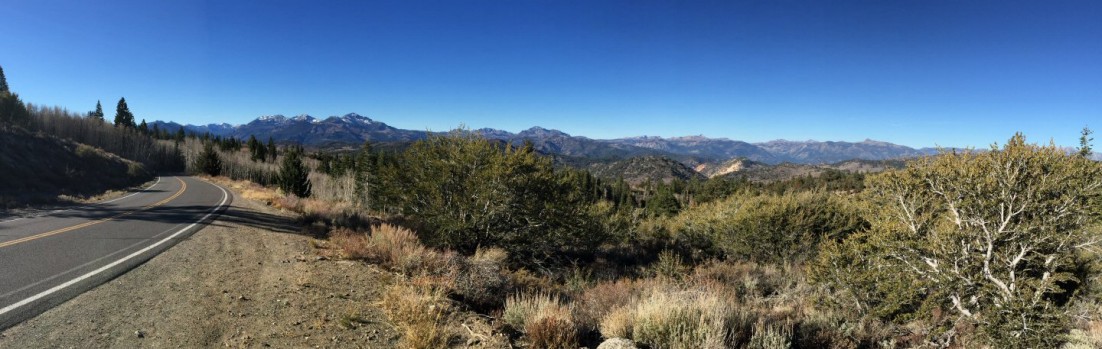
The temperature fell as I began to climb toward the pass, and blotches of yellows and reds more frequently peeked out from behind the evergreens. By the time I arrived at Kennedy Meadows (elevation 6,700 feet), it was about half an hour past sunrise, but in the shadows of this piñon-juniper forest, it was 27 degrees. In 10 more miles I climbed another 3,000 feet, emerged from the tree line, and the temperature would rise about 25 degrees.
I have a fondness for the high country — because its beauty is one of stark contrasts, in some ways harsh but fragile in others, with dwarfed pines scrapping out an existence against a background of granite — and this dramatic variation in temperatures is one of the most observable influences on that beauty. The simple expansion of water as it becomes ice slowly breaks down granite. The melting of that ice, and snow, as well as a general weathering of the landscape, breaks that granite into pieces that, through weather and the activities of insects and animals, can be mixed with decomposed plant matter to create a thin and rocky soil. It’s truly amazing that such infertile soil supports numerous conifers of all shapes and sizes.
The descent on the east side of the mountains leads down to the high desert, where desolation of this shrubland is interrupted by strings of trees, usually aspens in the canyons and pines elsewhere, following the course of the rivers and streams of the Walker watershed. The sun gathers strength here, but this morning its power would be contested by a layer of cold air that had established a foothold during the night.
River-side ice at 26 degrees that morning.
There’s always that time, between emerging from the artificial environmental cocoon of a vehicle and before the cold really starts to bite, that the air temperature never seems that cold. When I pulled alongside likely looking water, it was 26 degrees. I had given serious consideration to the idea it would be chilly, but now worried I hadn’t considered it seriously enough.
So with the thought that I had come too far and retreat wasn’t an option, I began the layering that I hoped would suffice. This was comprised of fleece pants under the waders, a wind-proof wading jacket over a fleece sweatshirt that was on top of my long sleeve shirt, and a well-worn, wide-brim canvas hat. Later I’d realize that my fingerless fishing gloves would have been a welcome addition.
As long as I kept moving, I avoided the long shadows that persisted as the sun hung low along its autumnal path. The water was 58 degrees, at the low end at which trout will be active, so I didn’t linger too long in one spot and moved frequently to cover as much water as possible.
This was an entirely new experience. My breath hung in the air, lingering as puffs of white. Skim ice crunched underfoot. My guides iced up within fifteen minutes. It was cold. So cold that I almost — almost — hoped that wouldn’t have to plunge my hand into the water to unhook a fish.
I would leave this first spot about an hour later, skunked but feeling that for that brief time, more than ever, that I couldn’t escape being part of nature.
From the start, we knew it’d require a different mindset. Not since our honeymoon 10½ years ago had Karen and I spent more than three or four days at the cabin. Eight days, however, clearly presented an opportunity for adventure; exploration at our own pace.
Potty-Mouth Wine
I did spend a couple of days fishing, but our destinations most days were only decided the evening before and sometimes only that morning. Our internal alarm clocks — or at least mine — meant I was up by oh-dark-thirty every morning, but that left plenty of time for a full breakfast if desired.
More than anything, we wandered; around town (Twain Harte) and through hill and dale. The higher elevations were colored by fall foliage while below 2,000 feet the grass of the oak woodlands was a pale gold.
Our day-long loop through Copperopolis, Angles Camp and Columbia took us through these distinctly different habitats, past the Sierra Conservation Center (aka prison) and over the very low New Melones Reservoir. In all my years in the area, never has New Melones looked less like a lake and more like a canyon than it did last week.
A map won’t tell you that Copperopolis has something of a split personality. The “real” Copperopolis — near Reeds Turnpike — was established in the 1860s and is a bit unique in that it was founded near a copper mine, not gold. But just north, near Hwy 4, is what looks like a Hollywood set plopped down in the middle of nowhere. It reminded me of the town of Lago, in High Plains Drifter; without the red, of course.
The buildings in Copperopolis Town Square tap historical architectural design of the mid and late 1800s, with retail shops and restaurants surrounding a small park with a gazebo, landscaped fountain and flag pole. Allowing for the fact that we were visiting on a Wednesday, during the fall, it was still quite vacant. It’s clearly designed with a pedestrian focus, including park benches, stone masonry walls and faux old-fashioned gas lamp posts. It was a nice enough place for a leisurely walk, with a stop for a root beer float in an old-style ice cream parlor.
The town square is nice enough, but peeking behind the curtain — actually one block off the main street — reveals paved streets complete with sidewalks and lightposts but devoid of homes; just dirt lots. While folks there will tell you Copperopolis Town Square is a phased development, I couldn’t help but wonder if these vacant lots were remnants of the recession. After all, developer Castle & Cooke did break ground on Copperopolis Town Square in April 2006.
Our loosely outlined plan was to stop in Angels Camp and Columbia before returning to the cabin. One suggestion: Don’t visit Angels Camp on a Wednesday; it seems as if half the businesses were closed.
The drive from Angels Camp to Columbia was interrupted, however, by my sudden veering on to Red Hill Road near Vallecito. During the summer I met a young man dispensing tastes at Mammoth Brewing Co. and learned in the course of conversation that his family owned Twisted Oak Winery. He was taking a break from the wine business to learn about beer, and after I mentioned the cabin in Twain Harte, he suggested a stop at the Twisted Oak tasting room in Murphys. I didn’t know the winery was in Vallecito until I saw the sign.
It was clear this was a place where the folks didn’t take themselves too seriously; the posted speed limit on the driveway is 9 mph. One wine label says it all: “*%#&@!” (described as a potty-mouth Rhone-style red blend). It’s a friendly place, and laughter pairs well with wine, so we lingered, bought some wine then headed on down the road.
We covered about 80 miles that day, agreeing to expand the circumference of our exploration the next time we can take the time to slow down.
It became clear we were enjoying ourselves and spending our time wisely when my sister emailed to ask if we had retired and not told her.
Not yet. But it sure was nice to spend a week acting as if we have.
I, for one, believe the best adventures of childhood were often found in the backyard or within one’s immediate neighborhood. As adults we learn of the wider world, of places that are ancient and historical, mysterious, full of wild lands and animals. It’s true, but a life lived yearning to visit these places can let the wonder right outside our door slip away unnoticed.
It was expected that this week at the cabin would entail local exploration, the type of exploration allowed only by ignoring the clock and following a path chosen in the few moments before our next step.
So it was that Karen and I found ourselves at Calaveras Big Trees State Park, after, of course, stopping along the way to pick up seasonal favorites: apple cider donuts and fresh-pressed cider. I was familiar with the area, which is about an hour away from the cabin, but only as an extension of my search for new fishing waters, namely Beaver Creek and the North Fork of the Stanislaus River. To explain briefly, Calaveras Big Trees was created to preserver two groves of some of the most massive giant sequoia trees. (Not always the tallest, but volumetrically the world’s largest trees.) These are Sequoiadendron giganteum, the inland relative to the perhaps more familiar coast redwood (Sequoia sempervirens.
The morning was spend wandering among these enormous trees, looking upward until our neck muscles complained during a hike that covered a few miles. But if the sequoias were the big stars of the show, big leaf maples and dogwoods were the flashy supporting players; this time of year decked out in shades of red, yellow and orange. Their dazzling colors proving that “Autumn is a second spring when every leaf is a flower.”1
Pictures are worth more words than I could possible write, so below is a gallery, a glimpse of what we saw.
1 Albert Camus
Looking through the forest.
Yellow Emerging
Dead Tree Amid Yellow
Looking Up
Red on a Background of Yellow
North Grove Trail
Us
“Old Bachelor”
Big Trees & Fall Color
Pacific Yew in one the few places it grows alongside sequoias.
Ask anyone who attended my club’s Eastern Sierra trip about the fish that made it to the net, and he’s likely to tell you it was about 18 inches. And that will be the truth.
For some of our group that was the length of one rainbow trout. For others, that total of 18 inches was the cumulative length of six brook trout. That’s just how it can play out in the Eastern Sierras.
The nice thing about an annual trip is that there always seems be to a landmark at which everyday life melts away and the focus shifts and sharpens to living in the present.
Morning above the West Walker River.
In this case, it occurs once the descent from Sonora Pass begins and the high desert stretches out in front of me. The route of choice this year was Hwy 108, as Hwy 120 (Tioga Road) was closed through mid September due to the Rim Fire. The usual commute traffic was there. Twice I would weave between cows meandering on the asphalt.
There are two maxims that apply to my fly fishing: (1) Get the skunk of as quickly as possible and (2) shaving serves no purpose. To address the first adage, I stopped at the West Walker River earlier than most fly fisherman would even take their first sip of coffee. Early enough to enjoy the stirring experience of hearing reveille echoing from the Marine Corps Mountain Warfare Training Center before my first cast.
Most people head for “the bend,” knowing that pods of planted trout can be found and, occasionally, a bigger fish might be found under a cut bank. But upstream, pocket water is a bigger draw for me.
West Walker Wild Rainbow
Pocket water slows me down considerably, and it’s a good thing. Besides the obvious, avoiding a fall and at least a sprain if not a broken bone or two, the pocket water in the Sierras tends to be favored by the better-looking wild fish, and they need to be stalked. With a slow and low approach, I found plenty of wild rainbows willing to play.
When the sun was high in the sky and hiding my profile consigned me to shade and leg cramps, it was time to head down Hwy 395 to Tom’s Place Resort, , which if you’ve ever been, is a bit more basic than the name implies. But the price is right. The rest of our group, totaling 12, would filter in throughout the afternoon.
After that, the real fishing would begin, to be followed by free flowing homemade beer, good food and plenty of lies.
Smoke from wildfires hindering the view out over Donnell Reservoir toward the Sacramento Valley.
Morning above the West Walker River.
West Walker Wild Rainbow
Morning commute traffic on the Sonora Pass Highway.
It’s been a bad year for water in California. The April opener was one of the best in years thanks to low water levels.
Next week we’ll see for ourselves what Eastern Sierra rivers and lakes look like four months later.
One guide recently referred to Bridgeport Reservoir as a “pond.” Bridgeport is so low that its outflow into the East Walker River has been tainted by algae — algae that usually floats closer to the surface of the reservoir — and now the river is regularly off color and weedier than usual. Lake Sabrina in the Bishop area is so low that the front (manmade) lake no longer exists. The level of Crowley Lake is better than might be expected, but low enough to concentrate fish in the deepest areas.
The route taken by myself and guys from the club will be dictated by the Rim Fire. Hwy 120 remains closed. An expectation that the fire might not be fully contained until Sept. 20 doesn’t lend any clarity as to when it might open.
That’s not a big issue for me. I usually head over Sonora Pass via Hwy 108, with stops at the West Walker River, Little Walker River or Molybdenite Creek.
Thankfully, there will be water to fish when we settle in at Tom’s Place Resort (which certainly isn’t the resort you might think it is). The Upper Owens is supposed to be in good shape. The Middle Owens is flowing at an unseasonably high level. I may head to the high country, visiting alpine lakes and streams where I hope the fish are already preparing for a long winter.
However it works out, there will be lies told over beer and good grub.
It was long ago decided that this blog was to be guided by a few simple rules; that it would be family focused and friendly, devoid of rants or advice, and mostly my space to write about the misadventures of my life.
Today, however, things are bit somber.
CalFire Rim Fire Incident Report
California’s fire season is shaping up to be one of historic proportions. The Rim Fire still raging near Yosemite Valley is one of 11 major fires currently burning in our bone-dry state. Those are only “major” fires. During the last few weeks, about 150 fires were sparked by lightning strikes. CalFire figures show that through the middle of August, 4,715 separate fires have burned the state — beating by a wide margin the historical annual average since 2008 of 3,000 fires. The Rim Fire is now the largest fire in the recorded history of the Sierra Nevada and, as of today, the 5th largest wildfire in California’s history.
In this moment, all eyes are understandably on the immediate danger to lives and property. Prayers are being said for the firefighters. This is devastation on an unimaginable scale.
As a fly fisherman, I can’t help but ask questions about the long-term impact on the many streams and rivers now stripped of bankside vegetation, and the fish in their waters. The extent of ecological damage won’t be understood for a long time. The intensity of the blaze — flames reportedly reached 100 to 200 feet as they shot up canyons — left nothing behind. While the Groveland Ranger District of the Stanislaus National Forest, the area predominately affected by the Rim Fire, has gone through cycles of intense wildfires, those fires have burned only small areas. (Decades of fire suppression and logging can be blamed.) Conjecture is that the Rim Fire, however, may have denuded up to a 1,000 acres.
The northern edge of the Rim Fire crossed the Clavey River, one of the longest undammed rivers in the Sierra Nevada, a designated wild and scenic river, and home to native coastal rainbow trout. The fire burned along extended stretches of the South and Middle Fork of the Tuolumne River as well as Cherry Creek, all waters known for fishing, whether stocked or wild fish. Many other but lesser known streams, streams I’ve found wild populations of trout, also fall within the boundaries of the Rim Fire.
The Clavey River
Relatively little is known about the effect of fire on fish populations. An admittedly hasty search of the Internet offers some insight. It’s clear that the effects of fire on fish populations can be complex, with dependency on the length of the event, size of the habitat, the home range of the fish, specialization of spawning habitats and the type of fish. Of course, most studies cite salmonid fishes (trout, salmon, chars, freshwater whitefishes and grayling) as the taxonomic group slowest to recover after a fire.
That said, the effect of fire on native salmonid populations can be highly variable, with extinctions observed in some isolated small headwater streams, but a quick rebound when a species’ home range extends to multiple tributaries within a single watershed.
In affected rivers, streams and lakes, fires can most notably affect water temperature and water chemistry as well as the local invertebrates, amphibians and fish. No longer shaded by trees and brush, water temperature can rise, reducing the solubility of dissolved oxygen. Absorption of ash can increase the water’s pH and impact nutrient levels in aquatic systems. Studies document five- to 60-fold increases in phosphate, nitrate, and ammonium concentrations in streams affected by fires that have swept through larger watersheds. Conditions in these waters returned to normal with a few weeks, but were later impacted by rain flushing additional ash and soil through the watershed.
It’s likely that the smallest streams will have most dramatically impacted by the fire. Though most people dance around the issue, this has been another drought year for California, and water levels are so low that any longish exposure to the fire may have “cooked” many of those small streams.
Nature, however, can be resilient; as long as we don’t get in the way. Anyone who’s visited Mt. St. Helens National Volcanic Monument can attest to that.
A beetle native to the Sierras, which has infrared receptors allowing it to detect fire, could be first on scene to feast on the blackened trees. They, in turn, will draw birds. New growth will sprout, creating forage for small mammals and, eventually, deer and bears.
We snuck out of the Bay Area on the Thursday a week ago for long weekend, planning to cram a bit of everything into the time we had.
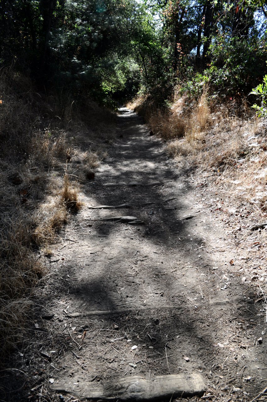
Railroad ties at the West Side Rail Grade trail head.
In a new spirit of exploring unknown parts of familiar territory, we ended up on the West Side Rail Grade the next morning. The trail — really a former narrow-gauge railbed — begins on Buchanan Road in Tuolumne City and is carved into the hillside above the North Fork Tuolumne River, on the north side of the canyon. It was christened in 1898 as the Hetch Hetchy & Yosemite Valley Railroad under the ownership of the West Side Lumber Co., which used narrow-gauge railroads in the Sierra Nevada Mountains until the 1960s. The HH&YV was primarily employed to haul fresh-cut logs from the sugar pine forests of eastern Tuolumne County to the West Side Lumber Mill in Tuolumne City.
The trailhead is just outside of town, and the first 100 yards are marked by decomposing railroad ties that look like worn steps. After that, most of the trail is exposed, which left us to bake in a remarkably hot morning sun. There are a couple places where benches and tables allow for a break in the shade, and a sprinkling of poison oak along the trail encourages one to stick to the well-worn path.
Though I’m not a history buff, per se, it’s a pleasant surprise to find remains of history in situ. About a mile down the trail we came across long portions of ties and rails, with the trail occasionally shifting from one side of the tracks to the other.
Rails of the Hetch Hetchy & Yosemite Valley Railroad.
The grade slopes gently downward, at least for as far as we hiked, and it would be a great place to break in some new boots. Had we continued the full 4½-plus miles, we could have soaked our toes in the North Fork of the Tuolumne River, near Basin Creek. (I originally discovered part of the West Side Rail trail while exploring Forest Service land above Long Barn, and while fishing an upstream portion of the Tuolumne, but have since determined that was another section of the trail that stretches from Hull Creek to the Clavey River, that that’s another hike for another time.)
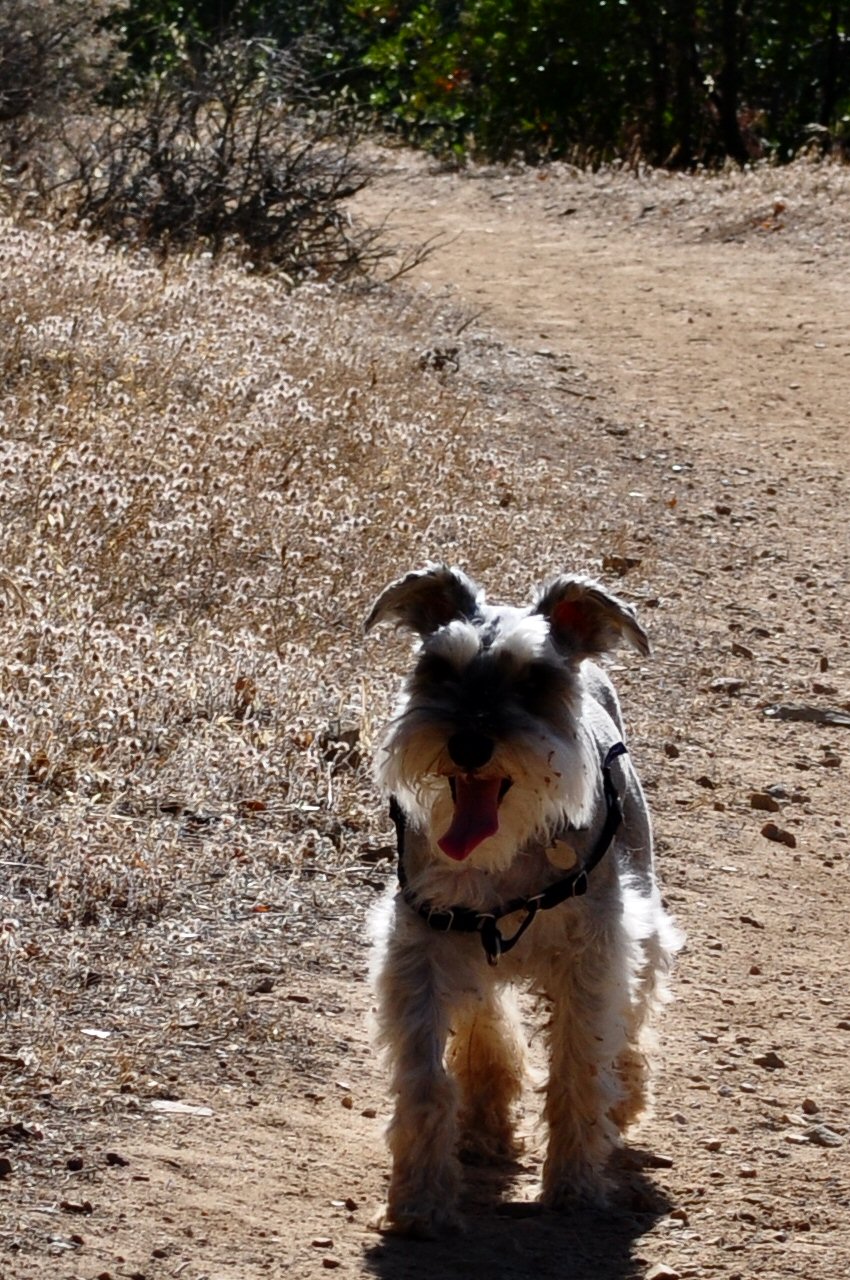
Hot and happy dog.
We met a few folks along the way: an overachiever who was jogging uphill and a few women who walk it almost every day, one of whom had made a dramatic move from the northern California coastal town of Bolinas to the much drier Sierra foothills.
With the full heat of the sun soon approaching, we left the exploration of a last blind curve for another time, and headed back. This day we had the dog with us and I don’t know if it was he or I who was panting more in the heat.
I have a feeling, though, that we’ll see more of this trail in the spring.
Railroad ties at the West Side Rail Grade trailhead.
Nevada waiting. I think he was always 10 yards ahead of us.
Looking downstream (west) from the West Side Rail Grade.
Rails of the Hetch Hetchy & Yosemite Valley Railroad.
Erosion threatening to dismantle part of the HH&YVRR.
The last bend before he turned around. “I’ll be back.”